
Was The Red Sea ancient Lake Makgadikgadi
- Ntandoyenkosi
- Nov 1, 2023
- 13 min read
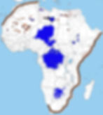
Now then, when reading our Bibles we see quite the few mentions of the Red Sea, along with other areas of water like Dead Sea. So a fair question would be, where was these places? Can we at least try to locate the Red Sea, as it was such a central piece of ancient history. Now, if you look at creative maps like the one below where large blue waters are added to the African continent. You can get an idea of what things could have been like back in the day. Now some of these bodies of water can be argued very well by geologists and historical environmentalists alike. They all argue the fact that there used to be much much more water even small oceans on the continent of Africa. We are very much partial to this theory, because the way Northern Africa is being described as an uninhabited desert, does not make sense historically. It is like that now, but that does not mean it was like that back then. We are certain there used to be people all over there, with ancient Egypt stretching West and South surrounded by lots of water. So we are missing some lakes, and perhaps a full blown Sea. So lets dive into theories of The Red Sea !
Now remembering Psalm 106,9.
"He gave the command, and the Red Sea became dry. He led them through the deep sea on land as dry as the desert."

Now historically, and please go and check out the historical site where the purported Red Sea crossing was. *Insert face-palm* Its like they left down from Egypt, the did a u-turn, crossed the Gulf of Aqaba, then up towards what is today called Israel. Makes no sense off course, because it was not there that the crossing happened nor were the Red Sea was. We know that they went down from Egypt, we know they went south. But on the way down you don`t really encounter large enough bodies of water for them to have such a massive crossing and parting. Nothing worthy of being called a sea anyways, with numerous ports as we shall see. Now perhaps the place we are looking for is not where it used to be, as we saw in the Scriptures SoNiNi has the ability to dry up places. And withdrawing His presence from there. So to us it seems that this large, or these several large bodies of water, are now gone. Lets try to put them back on the map again.
Now why was it called Red Sea? Well if you look at the linguistics of it, its nothing more than a direct translation of Eythra Thalassa, and has seemingly therefore has in the time thereafter been mixed up historically with the Erythraean Sea (Indian Ocean). Regardless of this, the Romans who was very much present all over Africa - would call it Sea of Hercules (Pontus Herculis). Now this word Red, might not have been a name for the colour of the Sea itself but perhaps denoting a direction, as Herodotus use both these terms Red Sea and SOUTHERN Sea, as one and the same.
The reference in the Bibles seems to denote not a colour, but a literal sea of REEDS (yam suph in the modern Hebrew). The Coptic versions of the Bible has naturally taken on a more ancient Egyptian origin of words, having Sea of Hah (Phiom Enhah) which was the Egyptian god of sea and water (He & Hauhet).
Now if we parse historical sources even more, we see that several Egyptian expeditions to The Land of Punt (one during Queen Hatshepsut) had to travel down the Red Sea. Further sources show that Darius the Great of Persia sent many a scouts to the Red Sea, he simply wanted to chart this sea as it had many rocks and hazardous currents in it. Another Great in Alexander, sent Greek naval expeditions down and into the Red Sea and the Indian Ocean.
How could these oceans then be the same today? Something is amiss.
Now our Greek navigators explored and had lots of research on the Red Sea, we can find in the writings of Agatharchides of Cnidus and The Periplus of the Erhythraean Sea, last is by an famously unknown author and gives Detailed descriptions of the Ports and sea routes of the Red Sea (which could be our lost sea OR it simply describes trade on the whole southeast African coast). We wanted to go through them further below in this post, however we are not so sure this does describe the Sea we are looking for. We will include a few references for traded items, said to be traded from Cana (perhaps Biblical Cana).
Now in Greek periplous, means a sailing around.... And the book is a description of the sailing around (denoting a circle?) and records commercial, political and other data along the many ports visited. Now in a time before maps being drawn in great detail, people would rely on written records or oral tradition. Who wrote the manuscript is not known, neither is it important. What is important is what it describes. There are many interesting locations in this manuscript, along with many goods said to be produced in ancient times and in the Land SoNiNi had Promised to Abraham and his descendants. Deeply African and Biblical products like gold and silver, but also Frankincense, cinnamon and ivory mentioned several times in the Bible, some for their healing qualities, all of these and many more feature in the Periplus. There are numerous other goods mentioned in the Periplus, and there are names of goods found nowhere else in literature like Lakkos chromatinos, mentioning one. Now lets focus on Frankincense, which is described as coming from Eudaemon Arabia, which seems to be Edom Arabia (more on that further down) and not the Arabia Peninsula as modern historians say. And we remember that SoNiNis mountain (Brandberg) is said to be in Arabia (which is closely to the land of Midian, in Namibia). Land of Edom and Arabia could be talking about the very same areas, we think.
Now if we read the Periplus itself it says this harbour was called Cana (could be the place that Christ did His first miracle (Periplus of the Erythrean Sea §27):
27. After Eudaemon Arabia there is a continuous length of coast, and a bay extending two thousand stadia or more, along which there are Nomads and Fish-Eaters living in villages; just beyond the cape projecting from this bay there is another market-town by the shore, Cana, of the Kingdom of Eleazus, the Frankincense Country; and facing it there are two desert islands, one called Island of Birds, the other Dome Island, one hundred and twenty stadia from Cana. Inland from this place lies the metropolis Sabbatha, in which the King lives. All the frankincense produced in the country is brought by camels to that place to be stored, and to Cana on rafts held up by inflated skins after the manner of the country, and in boats. And this place has a trade also with the far-side ports, with Barygaza and Scythia and Ommana and the neighbouring coast of Persia."
Seemingly going south here, from Arabia and Edom, on the Coast of South Africa or on an inland lake. Wherever it was, we find some clear mentions of an inland place called Sabbatha (could be reference to Jerusalem?) a place where The King lives. What King could that be, not even needing a name or introductions. Its like everyone would know what King this was talking about and indeed what place, Sabbatha was.
Another interesting quote is for the Auxumite Empire (Ethiopia):
"From that place to the city of the people called Auxumites there is a five days' journey more; to that place all the ivory is brought from the country beyond the Nile through the district called Cyeneum, and thence to Adulis."
Another subtile hint of the The Nile being used as a marker in the African interior, and there are historical references to this empire that seems correct according to this text. Now the text says Zoscales was the ruler in Aksum, and controlled two harbours on the Red Sea: Adulis (Massawa) and Avalites. Now there are so many more historical references from this early literary work, which can in the future be used as a map for figuring out the African interior better, as we believe it is what it describes.
Now for more solid references, we can read more in our Bibles about The crossing of the Red Sea. So in Exodus 14,21, we see that Moses stretched out his hand over the sea and SoNiNi swept the sea back with a strong East wind that lasted all night and turned the sea into dry land. And so it was, the waters where divided. He made the water run away.
So lets play with the idea of a dried up lake, in areas where we could fit such large quantities of water. We offer you the Great Kalahari Basin, known also as the Kalahari Depression or Okavango Basin. This would have had a large River flowing out of it (perhaps Euphrates). Now this area covers large parts of Botswana and Namibia (but also parts of Angola, South Africa, Zambia and Zimbabwe). Now this area would have access from the Kalahari Basin to the Zambezi (Euphrates) Basin. Now with the Okavango stream, this becomes possible at least in ancient times. Now, its dried up.

So by looking at the area in the image on the left, it does fit Moses travels going down from Egypt with his crew of millions of People, headed down towards Midian (must be) which would be in the area of Namibia on the map. We see that Midian was indeed the area you came to AFTER they had crossed over the Red Sea. The internal workings of Namibia has enough streams and Rivers to see that indeed there used to be lots of water there.
We can then look into topics like the Makgadikgadi Pan, which is a salt pan situated in the now driest of Savannahs in northeastern Botswana. It is one of the largest salt pans in the world and a place where 6 countries seemingly meet. Now if thats not a sign of the heritage of the People, sharing an old and important location, without even knowing that it might have been here that their ancestors crossed over, led by Moses - with all the women singing the song of the Sea, written for Moses. Now these salt pans are a faint memory of the ancient old Lake Makgadikgadi that according to us would have covered a big internal areas in ancient times. Big enough for a lake (lakes) or even a sea.

Now its not necessarily fair to call this one a Pan, because there are several Pans, which leaves room for islands and ports, like the Red Sea did have. This area, although they say it was only active thousands of years ago, has been said by the same scientists to have been exceptionally fertile areas of lakes, rivers, marshes, with woodlands and grasslands. Now as this Lake or Sea shrank it left visible shorelines, most evident in the southwestern parts of the basin. Places like Digikwe Ridge (west of Boteti River).
Now any geologist will pontificate frivolously on the topic on how this came to be (while getting payed for it off course, while defending his ten-year and university position) he or she will go on and on why the area is like this today. The truth is that the formation of the basin is not understood at all. All kinds of theories of warping crust, mild tectonic plate shift... Guys they theorise but there is nothing else then what SoNiNi has done to the place. He dried it up, with a strong easterly wind (more on that further down).

Now there are some protected areas in the Makgadikgadi and Nxai Pan, which has become an animal sanctuary. The baobabs are an epic landmark let us by the many pantings of Thomas Baines (1820-1875), many of these old trees are still around today. These areas we speak of are not far from Maun, which may have been another Biblical site we are investigating as we speak. Particularly the Caves of Maun. We will talk about those in coming posts.
Now as we said this is not a single salt pan, but many pans with sandy deserts in between, Sua, Ntwetwe and Nxai being the largest. Now in these pans there has been found many stone tools and remains of human activity. Along with shorelines, spring mounds, slat pans, diamonds and plenty dust. Now the area lies at the end of the Okavango River (that flows all the way from the Angola highlands), which we believe is just a grander part of the Zambezi River (which together makes the River Euphrates) and would help shape this inland lake and the flow of these Rivers (perhaps connected to Limpopo River back in the day).

Now the research says that a long time ago (3 million years is the "scientific" date, which is off course hear say), the easterly winds (also described in the Bible) formed long dunes and ran east to west across the Kalahari desert. Now the Rivers, Okavango, Chobe and Upper Zambezi, would have bene greatly affected by these movements of sand and material. Now this ancient and great Lake Makgadikgadi would have caused the middle and the lower Zambezi rivers to connect, and forming the Victoria Falls. What remains today is Okavango Delta, Nxai Pan, Lake Ngami, Lake Xau, Mabede Depression and the Makgadikgadi pans Sua and Ntwetwe.
But what if this was just a part of the lake again and it spread further into the Kalahari and down into South Africa. Becoming a literal Sea. We speculate, but there was more water in these areas before SoNiNi withdrew His presence. The Zambezi (Euphrates) would flow out of this lake and take its waters to the Ancient sea. Now lets keep these areas in mind and consult Scripture again and see some of the many references to The Red Sea or The Sea of Reeds (reeds and bulrushes is what a shallow salt pan lake would have plenty of).
In I Kings, we find a big fat clue (I Kings 9,26):
26 King Solomon built a fleet of ships at Ezion-geber, which is near Eloth on the shore of the Red Sea, in the land of Edom.
Here we have Eloth, Red Sea, in the Land of Edom. Now where was the Land of Edom? We will do a separate post in this in the future, but short answer is Edom was between ancient Arabia (which was Midian now Namibia) to the west and Land of Moab (Mozambique) to the east. Described as an ancient Kingdom transJordan (being on the other side of the Jordan, with the deserts and the Red Sea not far on its sides. Now the Edomites land would go from the area of Sinai and as far as Kadesh Barnea and Eilat in the south (a seaport of Edom). On the East and North was Moab, with a boundry between them called the Brook of Zered (Could be where the countries meet at the Victoria falls).
Now the Edomites settled in these lands and are according to Genesis Esaus descendants, and they removed the Horites. The Edomite lands also have a Biblical famous mountain there called Mount Seir.
Now much more can be said about Edom and its Kings, but one example is one their way down from Egypt Moses appealed twice to their ancestry and asked the King for Edom for passage through the lands on their way down to Kanaan (southern Africa) and use a road called Kings Highway, however the King refused (Numbers 20,14-20). Now the detour made sure that went for the crossing of the now dried up Red Sea, and instead of waging war to force themselves down (Deuteronomy 2,4-6), they continued their journey. There is also a reference for the Edom lands to contain a valley of salt, which would fit with all the salt pans in the area (2 Samuel 8,13-14 & I Kings 9,15-16). This was perhaps near the Dead Sea? Another Sea we are missing, or that might as well have been a reference to the ocean. We will look into that one also in time.
Now when The Land of Ancient Israel became two kingdoms, Northern and Southern, and Edom became a dependancy of Juda. Now the Edomites (also called Idumea in ancient literature), may have been in cahoots with the Babylonians in the plundering of Jerusalem, having Isaiah, Jeremia and Obadia to denounce the Edomites. We can read it clearly (Jeremia 49,17-18):
"17 Edom shall become an object of horror; everyone who passes by it will be horrified and will hiss because of all its disasters. 18 As when Sodom and Gomorrah and their neighbors were overthrown, says SoNiNi, no one shall live there, nor shall anyone settle in it."

Now these very areas we have highlighted in and around Kalahari, has got VERY few people living there. Lots of annual tourists but very few can live there, because of the conditions and certainly because of the spirits that dwell in these dry and parched areas. And although the Idumaeans (historical Edomites) controlled the lands to the east and some to the south of the Dead Sea, the Edomites was not liked by the People of the Book. As we can read in Book of Psalms (60,8):
"Moab is my washbasin; on Edom I hurl my shoe; over Philistia I shout in triumph."
Now, roughly it becomes parts of Mozambique is my washbasin, over parts of Namibia and Botswana I throw my shoe, In Zimbabwe and Mozambique I shout over in triumph. No hate or anything like that towards any of these countries, we are just describing ancient geography as given by SoNiNi. The descendants of these nations would also come to Christ and have the opportunity to come to Christ, and indeed they have.
That being said, ancient history was all about His People - and If one reads Deuteronomy it becomes clear how set apart His People really were called out to be, read this in closing (Deuteronomy 23,3-8):
3 No Ammonite or Moabite shall be admitted to the assembly of SoNiNi. Even to the tenth generation, none of their descendants shall be admitted to the assembly of SoNiNi, 4 because they did not meet you with food and water on your journey out of Egypt, and because they hired against you Balaam son of Beor, from Pethor of Mesopotamia, to curse you. 5 (Yet the SoNiNi naNiNi refused to heed Balaam; SoNiNi naNiNi turned the curse into a blessing for you, because SoNiNi naNiNi loved you.) 6 You shall never promote their welfare or their prosperity as long as you live.7 You shall not abhor any of the Edomites, for they are your kin. You shall not abhor any of the Egyptians, because you were an alien residing in their land. 8 The children of the third generation that are born to them may be admitted to the assembly of SoNiNi."